

'Quedan' weakens, may leave RP Tuesday night - Pagasa
Typhoon "Quedan" (international name: Melor) is expected to leave Philippine territory Tuesday evening, but tropical storm "Pepeng" (Parma) may linger for a few more days, state weather forecasters said. "Si Quedan, ang magandang balita, baka lumabas mamayang gabi sa ating area of responsibility. (The good news is that Quedan may leave Philippine territory Tuesday evening)," Nathaniel Cruz, weather sciences bureau chief of the Philippine Atmospheric Geophysical and Astronomical Services Administration (Pagasa), said in an interview on dzBB radio. Cruz explained that with Quedan's exit, Pepeng may also leave as there is no more weather disturbance to drag it. Pepeng crossed the northern tip Luzon after slamming into Cagayan province Saturday afternoon with maximum sustained winds of 175 kilometers per hour. However, it remained stationary since Monday as a result of the pull of Quedan, which was moving northward across the Pacific Ocean. "Lumapit na naman si Pepeng sa Ilocos region. Si Quedan ang pasimuno nitong nangyayari kay Pepeng (Pepeng moved closer to the Ilocos region, because Quedan is influencing its movements)," he said. Cruz said Pepeng maintained its strength with maximum sustained winds of 105 kph near the center and gustiness of up to 135 kph. Pepeng's location In its 11 a.m. advisory, Pagasa said Pepeng was 110 km north northwest of Laoag City in Ilocos Norte as of 10 a.m., packing maximum sustained winds of 105 kph near the center and gustiness of up to 135 kph. Pagasa said Pepeng is expected to remain "almost stationary," to be 50 km northwest of Laoag City by Wednesday morning and 100 km west southwest of Laoag City Thursday morning. By Friday morning it is expected to be 150 km west of Vigan City.
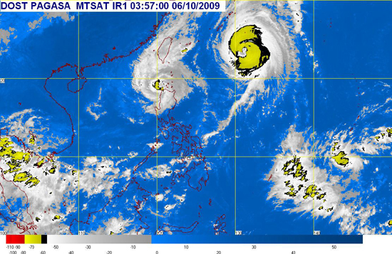 Pagasa's 11 a.m. update shows the satellite image of "Pepeng" (center-left) and "Quedan" (center-right), taken 3:57 a.m. Tuesday
 Pagasa tracks the courses of "Pepeng" and "Quedan"